sub:assertion {
<
http://eurovoc.europa.eu/3949> <
http://schema.org/description> "" ;
<
http://schema.org/name> "Applied sciences" ;
a <
http://schema.org/DefinedTerm> .
<
http://w3id.org/ro-id/rohub/model#funder/92fc96c5-54eb-4780-a390-e8b5515c76ac> <
http://purl.org/ontology/bibo/doi> "00k4n6c32" ;
<
http://schema.org/name> "European Commission" ;
a <
http://schema.org/Organization> .
<
https://orcid.org/0000-0002-1784-2920> <
http://schema.org/affiliation> "Simula Research Laboratory" ;
<
http://schema.org/email> "annef@simula.no" ;
<
http://schema.org/name> "Anne Fouilloux" ;
a <
http://xmlns.com/foaf/0.1/Agent> ;
<
https://w3id.org/dingo#orcid> "0000-0002-1784-2920" .
<
https://ror.org/00k4n6c32::101188256> <
http://schema.org/funder> <
http://w3id.org/ro-id/rohub/model#funder/92fc96c5-54eb-4780-a390-e8b5515c76ac> ;
<
http://schema.org/identifier> "00k4n6c32::101188256" ;
<
http://schema.org/name> "FAIR to Adapt to Climate Change" ;
<
http://schema.org/title> "FAIR to Adapt to Climate Change" ;
a <
http://schema.org/Grant> .
<
https://ror.org/00vn06n10> <
http://schema.org/email> "post@simula.no" ;
<
http://schema.org/identifier> "00vn06n10" ;
<
http://schema.org/name> "Simula Research Laboratory" ;
a <
http://schema.org/Organization> , <
http://xmlns.com/foaf/0.1/Agent> .
<
https://w3id.org/ro-id/0540cebe-9b10-45af-9db4-604e7a64ed60> <
http://schema.org/name> "Germany" ;
a <
https://w3id.org/ro/terms/earth-science#Concept> ;
<
https://w3id.org/ro/terms/earth-science#normScore> "4.342273307790549" ;
<
https://w3id.org/ro/terms/earth-science#score> "3.4" .
<
https://w3id.org/ro-id/0567f806-00e3-4120-9e01-229e58a87f26> <
http://schema.org/name> "edit" ;
a <
https://w3id.org/ro/terms/earth-science#Concept> ;
<
https://w3id.org/ro/terms/earth-science#normScore> "7.407407407407407" ;
<
https://w3id.org/ro/terms/earth-science#score> "5.8" .
<
https://w3id.org/ro-id/12fea67b-4679-4543-9d57-44440a7620c6> <
http://schema.org/name> "publishing" ;
a <
https://w3id.org/contentdesc#Domain> ;
<
https://w3id.org/ro/terms/earth-science#normScore> "100.0" ;
<
https://w3id.org/ro/terms/earth-science#score> "0.8" .
<
https://w3id.org/ro-id/15e54fde-611f-49cc-8951-e15c650f0cb2>
a <
http://purl.org/wf4ever/ro#ResearchObject> .
<
https://w3id.org/ro-id/1d1be42a-f453-4705-82e3-e10d610807d5> <
http://schema.org/name> "drug addict" ;
a <
https://w3id.org/ro/terms/earth-science#Concept> ;
<
https://w3id.org/ro/terms/earth-science#normScore> "4.597701149425288" ;
<
https://w3id.org/ro/terms/earth-science#score> "3.6" .
<
https://w3id.org/ro-id/1d39b6ad-25f6-4b03-8aca-fc77c1ed5330> <
http://schema.org/name> "http" ;
a <
https://w3id.org/ro/terms/earth-science#Lemma> ;
<
https://w3id.org/ro/terms/earth-science#normScore> "20.777027027027025" ;
<
https://w3id.org/ro/terms/earth-science#score> "12.3" .
<
https://w3id.org/ro-id/246eb18d-bf7f-4521-b47f-b88e24ece2d7> <
http://schema.org/name> "notebook" ;
a <
https://w3id.org/ro/terms/earth-science#Concept> ;
<
https://w3id.org/ro/terms/earth-science#normScore> "8.045977011494253" ;
<
https://w3id.org/ro/terms/earth-science#score> "6.3" .
<
https://w3id.org/ro-id/2dc852b1-ee72-4e32-8770-baeddd6ee513> <
http://schema.org/name> "earth resources and remote sensing" ;
a <
https://w3id.org/ro/terms/earth-science#NASA> ;
<
https://w3id.org/ro/terms/earth-science#normScore> "100.0" ;
<
https://w3id.org/ro/terms/earth-science#score> "0.9689354300498962" .
<
https://w3id.org/ro-id/2e473be3-ac4f-4804-a05f-395a06f0c30f> <
http://schema.org/name> "tutorial" ;
a <
https://w3id.org/ro/terms/earth-science#Concept> ;
<
https://w3id.org/ro/terms/earth-science#normScore> "12.132822477650064" ;
<
https://w3id.org/ro/terms/earth-science#score> "9.5" .
<
https://w3id.org/ro-id/35deaca0-ec97-468c-8c2c-4dab85ee0fd8> <
http://schema.org/name> "map" ;
a <
https://w3id.org/ro/terms/earth-science#Lemma> ;
<
https://w3id.org/ro/terms/earth-science#normScore> "8.277027027027028" ;
<
https://w3id.org/ro/terms/earth-science#score> "4.9" .
<
https://w3id.org/ro-id/3b2b42dd-d686-49fa-bd25-a3e8ec0bbd82> <
http://schema.org/name> "zones in Saarland" ;
a <
https://w3id.org/ro/terms/earth-science#Phrase> ;
<
https://w3id.org/ro/terms/earth-science#normScore> "12.794612794612794" ;
<
https://w3id.org/ro/terms/earth-science#score> "7.6" .
<
https://w3id.org/ro-id/3d07f69d-a2cb-4a97-8b2f-24c1f5946691> <
http://schema.org/name> "zone" ;
a <
https://w3id.org/ro/terms/earth-science#Concept> ;
<
https://w3id.org/ro/terms/earth-science#normScore> "5.874840357598978" ;
<
https://w3id.org/ro/terms/earth-science#score> "4.6" .
<
https://w3id.org/ro-id/4186caba-311c-4fe7-b9a5-7bedfaa9333d> <
http://schema.org/name> "editing" ;
a <
https://w3id.org/ro/terms/earth-science#Lemma> ;
<
https://w3id.org/ro/terms/earth-science#normScore> "8.783783783783784" ;
<
https://w3id.org/ro/terms/earth-science#score> "5.2" .
<
https://w3id.org/ro-id/47e46601-34db-4ed2-a16c-c7e63e3ff817> <
http://schema.org/name> "real-time editing" ;
a <
https://w3id.org/ro/terms/earth-science#Phrase> ;
<
https://w3id.org/ro/terms/earth-science#normScore> "23.737373737373737" ;
<
https://w3id.org/ro/terms/earth-science#score> "14.1" .
<
https://w3id.org/ro-id/4baa42ad-b336-483a-bc75-9c2cf6ed7640> <
http://schema.org/name> "JupyterGIS in Galaxy Europe" ;
a <
https://w3id.org/ro/terms/earth-science#Phrase> ;
<
https://w3id.org/ro/terms/earth-science#normScore> "25.084175084175083" ;
<
https://w3id.org/ro/terms/earth-science#score> "14.9" .
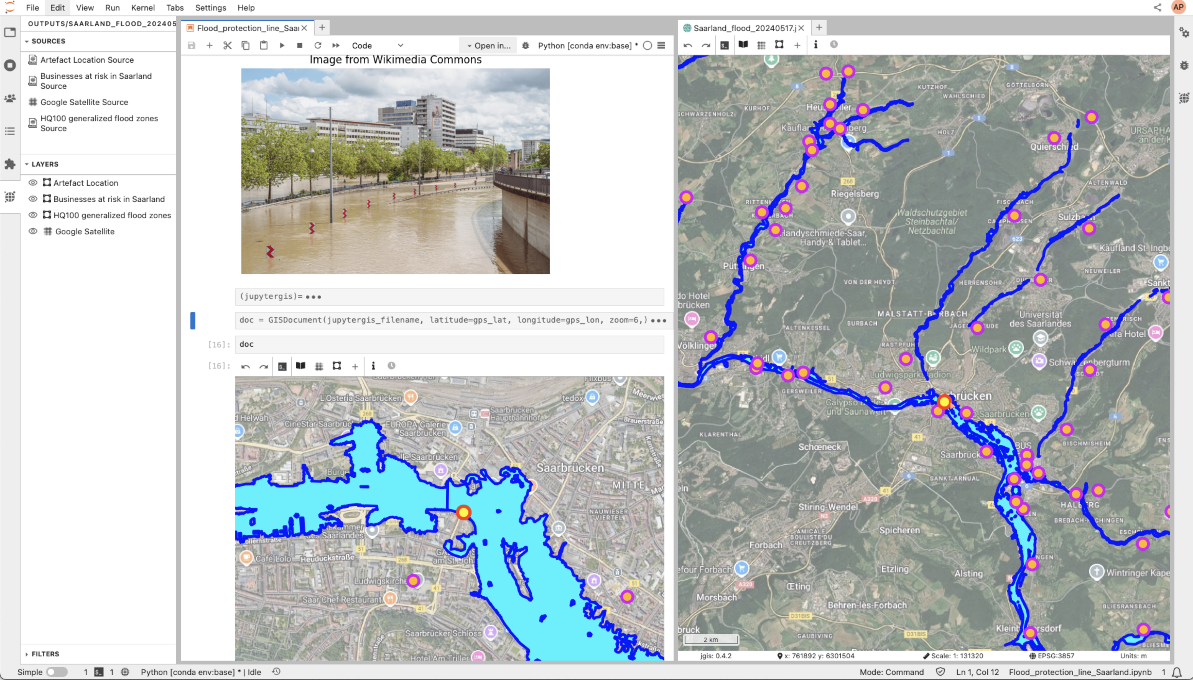
<
https://w3id.org/ro-id/500e0dba-c679-42fe-8afe-b8f8e1349831> <
http://schema.org/name> "We showcase the usage of JupyterGIS for creating geographical maps showing the HQ 100 flooding zones in Saarland along with images from Wikimedia Commons." ;
a <
https://w3id.org/ro/terms/earth-science#Sentence> ;
<
https://w3id.org/ro/terms/earth-science#normScore> "29.9618320610687" ;
<
https://w3id.org/ro/terms/earth-science#score> "15.7" .
<
https://w3id.org/ro-id/51f2e644-1083-4bc8-8184-ee7a7fe0a1e6> <
http://schema.org/name> "We use JupyterGIS on the UseGalaxy.eu. The tool can be launched from [JupyterGIS in Galaxy Europe](https://usegalaxy.eu/root?tool_id=interactive_tool_jupytergis_notebook). Please prior to use it, register to [usegalaxy.eu](https://usegalaxy.eu/login/start) and authenticate yourself before starting it." ;
a <
https://w3id.org/ro/terms/earth-science#Sentence> ;
<
https://w3id.org/ro/terms/earth-science#normScore> "36.83206106870229" ;
<
https://w3id.org/ro/terms/earth-science#score> "19.3" .
<
https://w3id.org/ro-id/572c411e-83d9-4fd8-b581-9724b2674243> <
http://schema.org/name> "usage of JupyterGIS" ;
a <
https://w3id.org/ro/terms/earth-science#Phrase> ;
<
https://w3id.org/ro/terms/earth-science#normScore> "21.043771043771045" ;
<
https://w3id.org/ro/terms/earth-science#score> "12.5" .
<
https://w3id.org/ro-id/588ada8d-a185-402e-8b60-3c17435110ee/#4a9c340c-3f55-4473-8ebc-9798b38b791a> <
http://schema.org/geo> <
https://w3id.org/ro-id/588ada8d-a185-402e-8b60-3c17435110ee/#c31df009-cac3-4389-9ee6-fc85383fc397> ;
<
http://schema.org/identifier> "4a9c340c-3f55-4473-8ebc-9798b38b791a" ;
<
http://schema.org/name> "POINT (7.0017099363030875 49.229107487031975)" ;
a <
http://schema.org/Place> .
<
https://w3id.org/ro-id/588ada8d-a185-402e-8b60-3c17435110ee/#c31df009-cac3-4389-9ee6-fc85383fc397> <
http://schema.org/latitude> "7.0017099363030875" ;
<
http://schema.org/longitude> "49.229107487031975" ;
<
http://schema.org/name> "POINT (7.0017099363030875 49.229107487031975)" ;
a <
http://schema.org/GeoCoordinates> .
<
https://w3id.org/ro-id/588ada8d-a185-402e-8b60-3c17435110ee/> <
http://purl.org/wf4ever/roevo#forkedAtTime> "2025-05-28 12:08:14.740275+00:00" ;
<
http://purl.org/wf4ever/roevo#forkedBy> "https://orcid.org/0000-0002-1784-2920" ;
<
http://schema.org/about> <
http://eurovoc.europa.eu/3949> ;
<
http://schema.org/author> <
https://orcid.org/0000-0002-1784-2920> ;
<
http://schema.org/contentLocation> <
https://w3id.org/ro-id/588ada8d-a185-402e-8b60-3c17435110ee/#4a9c340c-3f55-4473-8ebc-9798b38b791a> ;
<
http://schema.org/contentSize> 0 ;
<
http://schema.org/contentUrl> "https://api.rohub.org/api/ros/588ada8d-a185-402e-8b60-3c17435110ee/crate/download/" ;
<
http://schema.org/contributor> <
mailto:elifsu@simula.no> ;
<
http://schema.org/copyrightHolder> <
https://ror.org/00vn06n10> ;
<
http://schema.org/creator> <
https://orcid.org/0000-0002-1784-2920> ;
<
http://schema.org/dateCreated> "2025-05-17 17:15:18.830605+00:00" ;
<
http://schema.org/dateModified> "2025-05-28 12:41:54.042079+00:00" ;
<
http://schema.org/datePublished> "2025-05-17 17:15:18.830605+00:00" ;
<
http://schema.org/description> """## Flooding in Saarland
We showcase the usage of JupyterGIS for creating geographical maps showing the HQ 100 flooding zones in Saarland along with images from Wikimedia Commons.
These notebooks showcase how to use JupyterGIS.
We use JupyterGIS on the UseGalaxy.eu. The tool can be launched from [JupyterGIS in Galaxy Europe](https://usegalaxy.eu/root?tool_id=interactive_tool_jupytergis_notebook). Please prior to use it, register to [usegalaxy.eu](https://usegalaxy.eu/login/start) and authenticate yourself before starting it.
To help new users get started, there are two tutorials available:
- [Intro to JupyterGIS](https://jupytergis.readthedocs.io/en/latest/user_guide/tutorials/01-intro/index.html) a step-by-step guide for new users.
- [Collaborative Features Tutorial](https://training.galaxyproject.org/training-material/topics/climate/tutorials/jupytergis_collaboration/tutorial.html) — a guide for exploring real-time editing and shared annotations.
""" ;
<
http://schema.org/encodingFormat> "application/ld+json" ;
<
http://schema.org/funder> <
http://w3id.org/ro-id/rohub/model#funder/92fc96c5-54eb-4780-a390-e8b5515c76ac> ;
<
http://schema.org/funding> <
https://ror.org/00k4n6c32::101188256> ;
<
http://schema.org/hasPart> <
https://w3id.org/ro-id/588ada8d-a185-402e-8b60-3c17435110ee/resources/28c35687-b990-4137-bbdf-a1a2bc7f8920> , <
https://w3id.org/ro-id/588ada8d-a185-402e-8b60-3c17435110ee/resources/38bc1561-4eac-4e09-8bb3-b87a9502f889> , <
https://w3id.org/ro-id/588ada8d-a185-402e-8b60-3c17435110ee/resources/43b70064-85b8-452a-ba63-7ab11c065e62> , <
https://w3id.org/ro-id/588ada8d-a185-402e-8b60-3c17435110ee/resources/476d48c6-2114-4dfa-997d-a99e7b9c4839> , <
https://w3id.org/ro-id/588ada8d-a185-402e-8b60-3c17435110ee/resources/6070fc7c-fb39-4834-bf01-46bca1f56201> , <
https://w3id.org/ro-id/588ada8d-a185-402e-8b60-3c17435110ee/resources/67c0cbcb-4067-4ad1-ad2c-06e98aff714b> , <
https://w3id.org/ro-id/588ada8d-a185-402e-8b60-3c17435110ee/resources/6ee33c6a-6049-483f-84a0-e337c9c9e4d2> , <
https://w3id.org/ro-id/588ada8d-a185-402e-8b60-3c17435110ee/resources/8f18d6ab-38e3-45af-bc36-2935a5b33eca> , <
https://w3id.org/ro-id/588ada8d-a185-402e-8b60-3c17435110ee/resources/e4b83969-de3c-477a-9859-64fa5611645f> ;
<
http://schema.org/identifier> "https://w3id.org/ro-id/588ada8d-a185-402e-8b60-3c17435110ee" ;
<
http://schema.org/keywords> "flooding" , "saarland" ;
<
http://schema.org/license> <
https://creativecommons.org/licenses/by/4.0/legalcode> ;
<
http://schema.org/name> "Flooding in Saarland (Germany) with JupyterGIS - fork" , "Flooding in Saarland (Germany) with JupyterGIS" ;
<
http://schema.org/publisher> <
https://ror.org/00vn06n10> ;
<
http://w3id.org/ro-id/rohub/model#creation_mode> "MANUAL" ;
<
http://www.opengis.net/ont/geosparql#hasGeometry> "https://w3id.org/ro-id/588ada8d-a185-402e-8b60-3c17435110ee/24ad51f6-d7b4-4695-b93c-6de4f9a7aabe" ;
a <
http://purl.org/wf4ever/ro#ResearchObject> , <
http://purl.org/wf4ever/roevo#ForkedRO> , <
http://purl.org/wf4ever/roevo#LiveRO> , <
http://schema.org/Dataset> ;
prov:wasDerivedFrom "https://w3id.org/ro-id/15e54fde-611f-49cc-8951-e15c650f0cb2" ;
<
https://w3id.org/contentdesc#Domain> "https://w3id.org/ro-id/12fea67b-4679-4543-9d57-44440a7620c6" ;
<
https://w3id.org/contentdesc#Place> "https://w3id.org/ro-id/d26768e8-b368-4ad2-9d32-dca81dce9e2b" , "https://w3id.org/ro-id/f1474448-73d6-4d7e-919e-0134246ed966" ;
<
https://w3id.org/ro/terms/earth-science#Concept> "https://w3id.org/ro-id/0540cebe-9b10-45af-9db4-604e7a64ed60" , "https://w3id.org/ro-id/0567f806-00e3-4120-9e01-229e58a87f26" , "https://w3id.org/ro-id/1d1be42a-f453-4705-82e3-e10d610807d5" , "https://w3id.org/ro-id/246eb18d-bf7f-4521-b47f-b88e24ece2d7" , "https://w3id.org/ro-id/2e473be3-ac4f-4804-a05f-395a06f0c30f" , "https://w3id.org/ro-id/3d07f69d-a2cb-4a97-8b2f-24c1f5946691" , "https://w3id.org/ro-id/67a0f1a1-ee4c-4c41-b064-6fa4355a9792" , "https://w3id.org/ro-id/7ec7d31a-cfc7-412e-9e5a-1e6145094ab3" , "https://w3id.org/ro-id/a5af6ff5-a513-4ceb-9c10-942d1c6b6b38" , "https://w3id.org/ro-id/b172b4b1-fafb-4774-82bd-06d1b46dc290" , "https://w3id.org/ro-id/b8426843-c9aa-40de-bf19-934feb77f475" , "https://w3id.org/ro-id/c84eae9f-3b68-453e-8301-a561c19ae1c9" , "https://w3id.org/ro-id/fbd83c19-edd6-4933-a434-2c5bf9aaea6d" ;
<
https://w3id.org/ro/terms/earth-science#FieldOfResearch> "https://w3id.org/ro-id/c32fb828-0fb1-4761-a71e-b79058f885d1" , "https://w3id.org/ro-id/e80f74dd-9268-4215-85d5-210bf3b4eaad" ;
<
https://w3id.org/ro/terms/earth-science#Lemma> "https://w3id.org/ro-id/1d39b6ad-25f6-4b03-8aca-fc77c1ed5330" , "https://w3id.org/ro-id/35deaca0-ec97-468c-8c2c-4dab85ee0fd8" , "https://w3id.org/ro-id/4186caba-311c-4fe7-b9a5-7bedfaa9333d" , "https://w3id.org/ro-id/637a6d26-e7ec-4001-90f6-aa42a4f6a943" , "https://w3id.org/ro-id/76ca8190-4c71-4c02-b5d9-51aabcfcf912" , "https://w3id.org/ro-id/941022ff-01b0-4e3a-83d0-054f39ad6bc2" , "https://w3id.org/ro-id/a246196d-8e26-4342-b638-15f1663bfb07" ;
<
https://w3id.org/ro/terms/earth-science#NASA> "https://w3id.org/ro-id/2dc852b1-ee72-4e32-8770-baeddd6ee513" , "https://w3id.org/ro-id/8c2959e5-d5d3-4ffa-954f-db48cc009558" ;
<
https://w3id.org/ro/terms/earth-science#Phrase> "https://w3id.org/ro-id/3b2b42dd-d686-49fa-bd25-a3e8ec0bbd82" , "https://w3id.org/ro-id/47e46601-34db-4ed2-a16c-c7e63e3ff817" , "https://w3id.org/ro-id/4baa42ad-b336-483a-bc75-9c2cf6ed7640" , "https://w3id.org/ro-id/572c411e-83d9-4fd8-b581-9724b2674243" , "https://w3id.org/ro-id/d825b7f9-7b4c-4086-9946-a9230dbb2155" ;
<
https://w3id.org/ro/terms/earth-science#Sentence> "https://w3id.org/ro-id/500e0dba-c679-42fe-8afe-b8f8e1349831" , "https://w3id.org/ro-id/51f2e644-1083-4bc8-8184-ee7a7fe0a1e6" , "https://w3id.org/ro-id/de2ddebf-664e-4694-bd50-106d0429f112" ;
<
https://www.w3.org/ns/iana/link-relations/relation#cite-as> "Fouilloux, Anne, and ELİFSU FİLİZ. \"Flooding in Saarland (Germany) with JupyterGIS.\" ROHub. May 17 ,2025. https://w3id.org/ro-id/588ada8d-a185-402e-8b60-3c17435110ee." .
<
https://w3id.org/ro-id/588ada8d-a185-402e-8b60-3c17435110ee/24ad51f6-d7b4-4695-b93c-6de4f9a7aabe> <
http://www.opengis.net/ont/geosparql#asWKT> "POINT (7.0017099363030875 49.229107487031975)" ;
a <
http://www.opengis.net/ont/geosparql#Geometry> , <
http://www.opengis.net/ont/sf#Point> .
<
https://w3id.org/ro-id/588ada8d-a185-402e-8b60-3c17435110ee/resources/28c35687-b990-4137-bbdf-a1a2bc7f8920> <
http://schema.org/author> <
https://orcid.org/0000-0002-1784-2920> ;
<
http://schema.org/contentUrl> "https://fair2adapt.github.io/saarland-flooding/" ;
<
http://schema.org/creator> <
https://orcid.org/0000-0002-1784-2920> ;
<
http://schema.org/dateCreated> "2025-05-17 17:25:04.424197+00:00" ;
<
http://schema.org/dateModified> "2025-05-28 12:08:08.625385+00:00" ;
<
http://schema.org/description> "Jupyter Book (HTML rendered version) to showcase JupyterGiS in action using flooding event data from Saarland, Germany, available via the Urban Data Portal." ;
<
http://schema.org/license> <
https://creativecommons.org/licenses/by/4.0/legalcode> ;
<
http://schema.org/name> "Saarland flooding Jupyter Book (rendered HTML)" ;
<
http://schema.org/sdDatePublished> "2025-05-17 17:25:04.424197+00:00" ;
a <
http://purl.org/wf4ever/wf4ever#Resource> , <
http://schema.org/MediaObject> , <
https://w3id.org/ro-id/588ada8d-a185-402e-8b60-3c17435110ee/SoftwareDocumentation> .
<
https://w3id.org/ro-id/588ada8d-a185-402e-8b60-3c17435110ee/resources/38bc1561-4eac-4e09-8bb3-b87a9502f889> <
http://schema.org/author> <
https://orcid.org/0000-0002-1784-2920> ;
<
http://schema.org/contentUrl> "https://raw.githubusercontent.com/FAIR2Adapt/saarland-flooding/refs/heads/main/environment.yml" ;
<
http://schema.org/creator> <
https://orcid.org/0000-0002-1784-2920> ;
<
http://schema.org/dateCreated> "2025-05-28 06:22:48.754139+00:00" ;
<
http://schema.org/dateModified> "2025-05-28 12:08:06.376487+00:00" ;
<
http://schema.org/description> "environment.yml (Conda environment for Python JupyterGIS)" ;
<
http://schema.org/license> <
https://opensource.org/licenses/MIT> ;
<
http://schema.org/name> "environment.yml (JupyterGIS environment)" ;
<
http://schema.org/sdDatePublished> "2025-05-28 06:22:48.754139+00:00" ;
a <
http://purl.org/wf4ever/wf4ever#Resource> , <
http://purl.org/wf4ever/wf4ever#Script> , <
http://schema.org/MediaObject> .
<
https://w3id.org/ro-id/588ada8d-a185-402e-8b60-3c17435110ee/resources/43b70064-85b8-452a-ba63-7ab11c065e62> <
http://schema.org/author> <
https://orcid.org/0000-0002-1784-2920> ;
<
http://schema.org/contentUrl> "https://raw.githubusercontent.com/FAIR2Adapt/saarland-flooding/refs/heads/main/environment.lock.yml" ;
<
http://schema.org/creator> <
https://orcid.org/0000-0002-1784-2920> ;
<
http://schema.org/dateCreated> "2025-05-28 06:07:06.113808+00:00" ;
<
http://schema.org/dateModified> "2025-05-28 12:08:09.102494+00:00" ;
<
http://schema.org/description> "Python environment for executing the associated Jupyter notebook." ;
<
http://schema.org/license> <
https://opensource.org/licenses/MIT> ;
<
http://schema.org/name> "environment.lock.yml (conda environment)" ;
<
http://schema.org/sdDatePublished> "2025-05-28 06:07:06.113808+00:00" ;
a <
http://purl.org/wf4ever/wf4ever#Resource> , <
http://purl.org/wf4ever/wf4ever#Script> , <
http://schema.org/MediaObject> .
<
https://w3id.org/ro-id/588ada8d-a185-402e-8b60-3c17435110ee/resources/476d48c6-2114-4dfa-997d-a99e7b9c4839> <
http://schema.org/author> <
https://orcid.org/0000-0002-1784-2920> ;
<
http://schema.org/contentUrl> "https://raw.githubusercontent.com/FAIR2Adapt/saarland-flooding/refs/heads/main/notebooks/Flood_protection_line_Saarland.ipynb" ;
<
http://schema.org/creator> <
https://orcid.org/0000-0002-1784-2920> ;
<
http://schema.org/dateCreated> "2025-05-28 06:08:36.012998+00:00" ;
<
http://schema.org/dateModified> "2025-05-28 12:08:06.812992+00:00" ;
<
http://schema.org/description> "Flood_protection_line_Saarland.ipynb is a Jupyter Notebook ." ;
<
http://schema.org/license> <
https://opensource.org/licenses/MIT> ;
<
http://schema.org/name> "Flood_protection_line_Saarland.ipynb (Jupyter Notebook)" ;
<
http://schema.org/sdDatePublished> "2025-05-28 06:08:36.012998+00:00" ;
a <
http://purl.org/wf4ever/wf4ever#Resource> , <
http://schema.org/MediaObject> , <
https://w3id.org/ro/terms/earth-science#JupyterNotebook> ;
<
https://schema.org/softwareRequirements> "https://w3id.org/ro-id/588ada8d-a185-402e-8b60-3c17435110ee/resources/85ba47e2-3608-40f7-ade8-bfd40a8fc19d" .
<
https://w3id.org/ro-id/588ada8d-a185-402e-8b60-3c17435110ee/resources/6070fc7c-fb39-4834-bf01-46bca1f56201> <
http://schema.org/author> <
https://orcid.org/0000-0002-1784-2920> ;
<
http://schema.org/contentUrl> "https://github.com/FAIR2Adapt/saarland-flooding.git" ;
<
http://schema.org/creator> <
https://orcid.org/0000-0002-1784-2920> ;
<
http://schema.org/dateCreated> "2025-05-17 17:23:09.941511+00:00" ;
<
http://schema.org/dateModified> "2025-05-28 12:08:09.818748+00:00" ;
<
http://schema.org/description> "This Github repository contains the latest version of the jupyter notebooks showcasing JupyterGIS." ;
<
http://schema.org/license> <
https://opensource.org/licenses/MIT> ;
<
http://schema.org/name> "Saarland-flooding (Github repository)" ;
<
http://schema.org/sdDatePublished> "2025-05-17 17:23:09.941511+00:00" ;
a <
http://purl.org/wf4ever/wf4ever#Resource> , <
http://schema.org/MediaObject> , <
https://w3id.org/ro/terms/earth-science#SWDocumentation> .
<
https://w3id.org/ro-id/588ada8d-a185-402e-8b60-3c17435110ee/resources/67c0cbcb-4067-4ad1-ad2c-06e98aff714b> <
http://schema.org/author> <
https://orcid.org/0000-0002-1784-2920> ;
<
http://schema.org/contentSize> 2788165 ;
<
http://schema.org/contentUrl> "https://api.rohub.org/api/resources/67c0cbcb-4067-4ad1-ad2c-06e98aff714b/download/" ;
<
http://schema.org/creator> <
https://orcid.org/0000-0002-1784-2920> ;
<
http://schema.org/dateCreated> "2025-05-17 17:20:36.705228+00:00" ;
<
http://schema.org/dateModified> "2025-05-28 12:08:08.186162+00:00" ;
<
http://schema.org/description> "Flood in Saarland with JupyterGIS." ;
<
http://schema.org/encodingFormat> "image/png" ;
<
http://schema.org/license> <
https://creativecommons.org/licenses/by/4.0/legalcode> ;
<
http://schema.org/name> "flood_in_saarland_with_jqgis.png" ;
<
http://schema.org/sdDatePublished> "2025-05-17 17:20:36.705228+00:00" ;
a <
http://purl.org/wf4ever/roterms#Sketch> , <
http://purl.org/wf4ever/wf4ever#Resource> , <
http://schema.org/MediaObject> .
<
https://w3id.org/ro-id/588ada8d-a185-402e-8b60-3c17435110ee/resources/6ee33c6a-6049-483f-84a0-e337c9c9e4d2> <
http://schema.org/author> <
https://orcid.org/0000-0002-1784-2920> ;
<
http://schema.org/contentUrl> "https://raw.githubusercontent.com/FAIR2Adapt/saarland-flooding/refs/heads/main/notebooks/get_typename_from_WFS.ipynb" ;
<
http://schema.org/creator> <
https://orcid.org/0000-0002-1784-2920> ;
<
http://schema.org/dateCreated> "2025-05-28 06:10:42.644758+00:00" ;
<
http://schema.org/dateModified> "2025-05-28 12:08:04.665895+00:00" ;
<
http://schema.org/description> """## Get data layer names from WFS service URL
**Learn how to get the typename (e.g. data layers) which are requested for querying WFS services**""" ;
<
http://schema.org/license> <
https://opensource.org/licenses/MIT> ;
<
http://schema.org/name> "get_typename_from_WFS.ipynb (Jupyter Notebook)" ;
<
http://schema.org/sdDatePublished> "2025-05-28 06:10:42.644758+00:00" ;
a <
http://purl.org/wf4ever/wf4ever#Resource> , <
http://schema.org/MediaObject> , <
https://w3id.org/ro/terms/earth-science#JupyterNotebook> .
<
https://w3id.org/ro-id/588ada8d-a185-402e-8b60-3c17435110ee/resources/8f18d6ab-38e3-45af-bc36-2935a5b33eca> <
http://schema.org/author> <
https://orcid.org/0000-0002-1784-2920> ;
<
http://schema.org/contentUrl> "https://raw.githubusercontent.com/FAIR2Adapt/saarland-flooding/refs/heads/main/notebooks/Hamburg_urban_data_portal_WFS.ipynb" ;
<
http://schema.org/creator> <
https://orcid.org/0000-0002-1784-2920> ;
<
http://schema.org/dateCreated> "2025-05-28 06:12:02.439269+00:00" ;
<
http://schema.org/dateModified> "2025-05-28 12:08:14.693939+00:00" ;
<
http://schema.org/description> """## Get data from the Hamburg Urban Data Portal using WFS
**Learn how to access vector data from the Hamburg Urban Data Portal with WFS**""" ;
<
http://schema.org/license> <
https://opensource.org/licenses/MIT> ;
<
http://schema.org/name> "Hamburg_urban_data_portal_WFS.ipynb (Jupyter Notebook)" ;
<
http://schema.org/sdDatePublished> "2025-05-28 06:12:02.439269+00:00" ;
a <
http://purl.org/wf4ever/wf4ever#Resource> , <
http://schema.org/MediaObject> , <
https://w3id.org/ro/terms/earth-science#JupyterNotebook> .
<
https://w3id.org/ro-id/588ada8d-a185-402e-8b60-3c17435110ee/resources/e4b83969-de3c-477a-9859-64fa5611645f> <
http://schema.org/author> <
https://orcid.org/0000-0002-1784-2920> ;
<
http://schema.org/contentUrl> "https://doi.org/10.5281/zenodo.15470110" ;
<
http://schema.org/creator> <
https://orcid.org/0000-0002-1784-2920> ;
<
http://schema.org/dateCreated> "2025-05-20 08:44:57.687928+00:00" ;
<
http://schema.org/dateModified> "2025-05-28 12:08:07.043396+00:00" ;
<
http://schema.org/description> "Saarland flooding (Galaxy History) with outputs and executed notebooks." ;
<
http://schema.org/license> <
https://creativecommons.org/licenses/by/4.0/legalcode> ;
<
http://schema.org/name> "Saarland flooding (Galaxy History)" ;
<
http://schema.org/sdDatePublished> "2025-05-20 08:44:57.687928+00:00" ;
a <
http://purl.org/wf4ever/ro#ResearchObject> , <
http://purl.org/wf4ever/wf4ever#Resource> , <
http://schema.org/MediaObject> .
<
https://w3id.org/ro-id/588ada8d-a185-402e-8b60-3c17435110ee/ro-crate-metadata.json>
dct:conformsTo <
https://w3id.org/ro/crate/1.1> ;
<
http://schema.org/about> <
https://w3id.org/ro-id/588ada8d-a185-402e-8b60-3c17435110ee/> ;
a <
http://schema.org/CreativeWork> .
<
https://w3id.org/ro-id/637a6d26-e7ec-4001-90f6-aa42a4f6a943> <
http://schema.org/name> "tutorial" ;
a <
https://w3id.org/ro/terms/earth-science#Lemma> ;
<
https://w3id.org/ro/terms/earth-science#normScore> "14.020270270270272" ;
<
https://w3id.org/ro/terms/earth-science#score> "8.3" .
<
https://w3id.org/ro-id/67a0f1a1-ee4c-4c41-b064-6fa4355a9792> <
http://schema.org/name> "annotation" ;
a <
https://w3id.org/ro/terms/earth-science#Concept> ;
<
https://w3id.org/ro/terms/earth-science#normScore> "5.874840357598978" ;
<
https://w3id.org/ro/terms/earth-science#score> "4.6" .
<
https://w3id.org/ro-id/76ca8190-4c71-4c02-b5d9-51aabcfcf912> <
http://schema.org/name> "notebook" ;
a <
https://w3id.org/ro/terms/earth-science#Lemma> ;
<
https://w3id.org/ro/terms/earth-science#normScore> "9.628378378378377" ;
<
https://w3id.org/ro/terms/earth-science#score> "5.7" .
<
https://w3id.org/ro-id/7ec7d31a-cfc7-412e-9e5a-1e6145094ab3> <
http://schema.org/name> "real time" ;
a <
https://w3id.org/ro/terms/earth-science#Concept> ;
<
https://w3id.org/ro/terms/earth-science#normScore> "4.725415070242657" ;
<
https://w3id.org/ro/terms/earth-science#score> "3.7" .
<
https://w3id.org/ro-id/8c2959e5-d5d3-4ffa-954f-db48cc009558> <
http://schema.org/name> "geosciences" ;
a <
https://w3id.org/ro/terms/earth-science#NASA> ;
<
https://w3id.org/ro/terms/earth-science#normScore> "100.0" ;
<
https://w3id.org/ro/terms/earth-science#score> "0.9689354300498962" .
<
https://w3id.org/ro-id/941022ff-01b0-4e3a-83d0-054f39ad6bc2> <
http://schema.org/name> "JupyterGIS" ;
a <
https://w3id.org/ro/terms/earth-science#Lemma> ;
<
https://w3id.org/ro/terms/earth-science#normScore> "24.155405405405403" ;
<
https://w3id.org/ro/terms/earth-science#score> "14.3" .
<
https://w3id.org/ro-id/a246196d-8e26-4342-b638-15f1663bfb07> <
http://schema.org/name> "Saarland" ;
a <
https://w3id.org/ro/terms/earth-science#Lemma> ;
<
https://w3id.org/ro/terms/earth-science#normScore> "14.358108108108107" ;
<
https://w3id.org/ro/terms/earth-science#score> "8.5" .
<
https://w3id.org/ro-id/a5af6ff5-a513-4ceb-9c10-942d1c6b6b38> <
http://schema.org/name> "headquarters" ;
a <
https://w3id.org/ro/terms/earth-science#Concept> ;
<
https://w3id.org/ro/terms/earth-science#normScore> "4.725415070242657" ;
<
https://w3id.org/ro/terms/earth-science#score> "3.7" .
<
https://w3id.org/ro-id/b172b4b1-fafb-4774-82bd-06d1b46dc290> <
http://schema.org/name> "usage" ;
a <
https://w3id.org/ro/terms/earth-science#Concept> ;
<
https://w3id.org/ro/terms/earth-science#normScore> "6.257982120051087" ;
<
https://w3id.org/ro/terms/earth-science#score> "4.9" .
<
https://w3id.org/ro-id/b8426843-c9aa-40de-bf19-934feb77f475> <
http://schema.org/name> "map" ;
a <
https://w3id.org/ro/terms/earth-science#Concept> ;
<
https://w3id.org/ro/terms/earth-science#normScore> "7.0242656449553005" ;
<
https://w3id.org/ro/terms/earth-science#score> "5.5" .
<
https://w3id.org/ro-id/c32fb828-0fb1-4761-a71e-b79058f885d1> <
http://schema.org/name> "atmospheric sciences" ;
a <
https://w3id.org/ro/terms/earth-science#FieldOfResearch> ;
<
https://w3id.org/ro/terms/earth-science#normScore> "100.0" ;
<
https://w3id.org/ro/terms/earth-science#score> "0.571331262588501" .
<
https://w3id.org/ro-id/c84eae9f-3b68-453e-8301-a561c19ae1c9> <
http://schema.org/name> "http" ;
a <
https://w3id.org/ro/terms/earth-science#Concept> ;
<
https://w3id.org/ro/terms/earth-science#normScore> "17.11366538952746" ;
<
https://w3id.org/ro/terms/earth-science#score> "13.4" .
<
https://w3id.org/ro-id/d26768e8-b368-4ad2-9d32-dca81dce9e2b> <
http://schema.org/name> "Germany" ;
a <
https://w3id.org/contentdesc#Place> ;
<
https://w3id.org/ro/terms/earth-science#wikidata> "https://www.wikidata.org/wiki/Q183" .
<
https://w3id.org/ro-id/d825b7f9-7b4c-4086-9946-a9230dbb2155> <
http://schema.org/name> "features tutorial" ;
a <
https://w3id.org/ro/terms/earth-science#Phrase> ;
<
https://w3id.org/ro/terms/earth-science#normScore> "17.34006734006734" ;
<
https://w3id.org/ro/terms/earth-science#score> "10.3" .
<
https://w3id.org/ro-id/de2ddebf-664e-4694-bd50-106d0429f112> <
http://schema.org/name> "Flooding in Saarland (Germany) with JupyterGIS." ;
a <
https://w3id.org/ro/terms/earth-science#Sentence> ;
<
https://w3id.org/ro/terms/earth-science#normScore> "33.20610687022901" ;
<
https://w3id.org/ro/terms/earth-science#score> "17.4" .
<
https://w3id.org/ro-id/e80f74dd-9268-4215-85d5-210bf3b4eaad> <
http://schema.org/name> "earth sciences" ;
a <
https://w3id.org/ro/terms/earth-science#FieldOfResearch> ;
<
https://w3id.org/ro/terms/earth-science#normScore> "100.0" ;
<
https://w3id.org/ro/terms/earth-science#score> "0.571331262588501" .
<
https://w3id.org/ro-id/f1474448-73d6-4d7e-919e-0134246ed966> <
http://schema.org/name> "Saarland" ;
a <
https://w3id.org/contentdesc#Place> ;
<
https://w3id.org/ro/terms/earth-science#wikidata> "https://www.wikidata.org/wiki/Q1201" .
<
https://w3id.org/ro-id/fbd83c19-edd6-4933-a434-2c5bf9aaea6d> <
http://schema.org/name> "Saarland" ;
a <
https://w3id.org/ro/terms/earth-science#Concept> ;
<
https://w3id.org/ro/terms/earth-science#normScore> "11.877394636015328" ;
<
https://w3id.org/ro/terms/earth-science#score> "9.3" .
<
mailto:elifsu@simula.no> <
http://schema.org/email> "elifsu@simula.no" ;
<
http://schema.org/name> "ELİFSU FİLİZ" ;
a <
http://xmlns.com/foaf/0.1/Agent> .
}